Components of Maps


Components of Maps
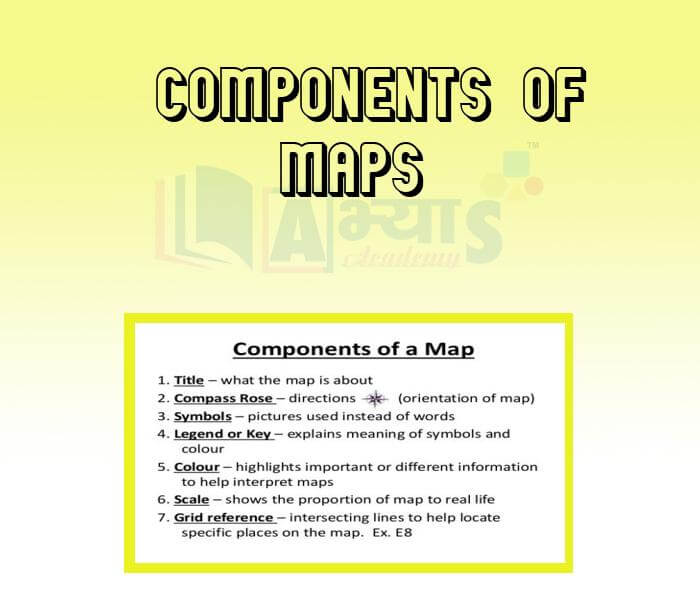
Components of maps: Title, Distance, direction and symbol, latitude and longitude.Title: It states the purpose or theme of the map. For Example, India-Political, world- Physical, Chennai-Road Map.Distance: Maps are drawings, which reduce the entire world or a part of it to fit on a sheet of paper. The scale of a map is defined as the ratio between the distance on the map and the corresponding distance on the ground. The scale of a map can be represented in different ways:-Verbal or Statement Scale: A verbal scale describes the scale in words. For Example: ‘One centimeter on the map is equal to one kilometer on the ground.Representative Fraction (RF): A representative fraction represents the scale of a map in terms of a fraction or a ratio. For example, if 1 cm on the map represents 1 Km (equal to 1,00,000 cm) on the ground, we say the RF of the map is:
or 1:1,00,000Linear Scale: A linear scale is one where the scale of the map is represented by a straight with uniformly spaced divisions.Large scale and small scale maps: When large areas like continents or countries are to be shown on paper, then we use a small scale. For example 5 cm. on the map shows 500 km, of the ground. It is called a small scale map.When a small area like your village or town is to be shown on paper, then we use a large scale that is 5 cm. on the map shows 500 meters only on the ground. It is called a large scale map.
Large scale maps | Small scale maps |
· Cover smaller land area on the map. · Provide a great deal of detail · e.g., a city map or a street map or a village map · Scale=1:100,000 | · Cover larger land area on the map. · Provide small amount of details · e.g., world map in an atlas · Scale=1:10,000,000 |
Direction: Most maps contain an arrow marked with the letter ‘N’ at the upper right hand corner. This arrow shows the north direction. It is called the north line. There are four major directions, north, south, east and west. They are called cardinal points. Other four intermediate directions are north-east (NE), south east (SE), south west (SW) and north-west (NW).
The direction of a place can be finding with the help of a compass. It is an instrument used to find out main directions. Its magnetic needle always points towards north-south direction.
Symbols: It is the third important component of a map. It is not possible to draw on a map the actual shape and size of different features such as buildings, roads, bridges, trees, railway lines or a well. So, they are shown by using certain letters, shades, colors, pictures and lines these symbols give a lot of information in a limited space. With the use of these symbols, maps can be drawn easily and are simple to read. Maps have a universal language that can be understood by all. There is an international agreement regarding the use of these symbols. These are called conventional symbols.
A scale is necessary ______________ | |||
| Right Option : A | |||
| View Explanation | |||
A compass is used _____________ | |||
| Right Option : B | |||
| View Explanation | |||
Cardinal points refer to ______________ | |||
| Right Option : C | |||
| View Explanation | |||
Students / Parents Reviews [10]
Abhyas is a complete education Institute. Here extreme care is taken by teacher with the help of regular exam. Extra classes also conducted by the institute, if the student is weak.

Om Umang
10thAbout Abhyas metholodology the teachers are very nice and hardworking toward students.The Centre Head Mrs Anu Sethi is also a brilliant teacher.Abhyas has taught me how to overcome problems and has always taken my doubts and suppoeted me.

Shreya Shrivastava
8thAbhyas Methodology is very good. It is based on according to student and each child manages accordingly to its properly. Methodology has improved the abilities of students to shine them in future.

Manish Kumar
10thI have spent a wonderful time in Abhyas academy. It has made my reasoning more apt, English more stronger and Maths an interesting subject for me. It has given me a habbit of self studying

Yatharthi Sharma
10thOne of the best institutes to develope a child interest in studies.Provides SST and English knowledge also unlike other institutes. Teachers are co operative and friendly online tests andPPT develope practical knowledge also.

Aman Kumar Shrivastava
10thA marvelous experience with Abhyas. I am glad to share that my ward has achieved more than enough at the Ambala ABHYAS centre. Years have passed on and more and more he has gained. May the centre flourish and develop day by day by the grace of God.
Archit Segal
7thMy experience was very good with Abhyas academy. I am studying here from 6th class and I am satisfied by its results in my life. I improved a lot here ahead of school syllabus.

Ayan Ghosh
8thIt was good as the experience because as we had come here we had been improved in a such envirnment created here.Extra is taught which is beneficial for future.

Eshan Arora
8thMy experience with Abhyas is very good. I have learnt many things here like vedic maths and reasoning also. Teachers here first take our doubts and then there are assignments to verify our weak points.

Shivam Rana
7thBeing a parent, I saw my daughter improvement in her studies by seeing a good result in all day to day compititive exam TMO, NSO, IEO etc and as well as studies. I have got a fruitful result from my daughter.